
Formation: 1870. The origin of the name: The name “the North-Western Territories,” initially assigned by the British government, once referred to all the lands held by the Hudson’s Bay Company.
TIME: 5 AM MST = noon GMT.
A vast area of forests and tundra, the Northwest Territories is one-third of Canada’s total landmass, stretching from the eastern to western extremities of the country. It has a rich natural environment but is home to more than 60% of Canada’s biodiversity due to its largely uninhabited regions. The creation in 1999 of Nunavut, out of the eastern portion of the Northwest Territories, reduced the latter’s size by more than half.
The Northwest Territories are the northern expansions of Canada, reaching beyond the Arctic Circle, and are bordered by Nunavut in the East, British Columbia, Alberta, and Saskatchewan in the South, and the Yukon to the West. Yellowknife is the capital city of this territory. The Northwest Territories region is 1,346,106 square km / 519,735 square miles. The population is 41,070.
Two main types of logging are seen on the timberline. One type is the taiga or boreal forest, which spans from near the Mackenzie River delta in Canada to Manitoba and the Yukon. It’s roughly parallel to the border with Nunavut. The barren grounds north and East of the timberline are flat, poorly drained lowlands over a billion years old. The conditions support surface vegetation depending on the soil and climate. The Mackenzie Mountains in the west and southwest contain the highest and most rugged relief in the territories; elevations reach 2,730 meters / 9,062 feet near Mount Sir James McBrien.
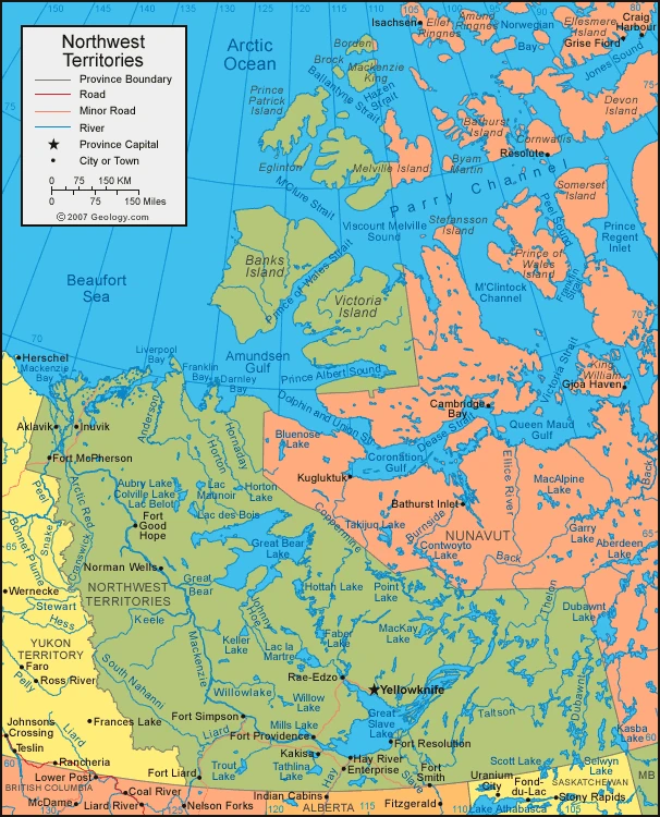
Map of the Northwest Territories
In the west-central portion of provinces and territories, the environment in the Mackenzie Lowlands is favorable for herbaceous plants when there’s no frost. The environment consists of black and white spruce mixed with deciduous species. Approximately 70 days are frost-free, but that doesn’t stop wildflowers from flourishing. The region sustains many valuable fur-bearing animals, such as muskrats and beavers. Moose, wolves, black bears, and grizzly bears are commonly found. Mountain sheep and mountain goats also live there.
The climate of the Mackenzie Lowlands is still cold, but not as cold as in other places. Due to the climate, there’s only a limited amount of time that you could use to navigate the Mackenzie River, and there’s also permafrost, which causes construction problems.
North and East of the Mackenzie Lowlands and the tree line, the terrain changes to that of the ancient and rocky Precambrian mass known as the Canadian Shield, the western edge of which is straddled by the two largest lakes in the territories – Great Bear Lake (12,096 square miles [31,328 square km]) and Great Slave Lake (11,030 square miles [28,568 square km]). The Arctic Islands are remnant mountains formed over 300 to 400 million years ago. The growth of trees is stunted and eventually disappears, so a plant-less wilderness called the tundra takes its place. The soil in these barren lands tends to be sand or ice, with few plants but providing many types of animal life. The musk ox was at risk of extinction until the Canadian government protected it in the early 20th century. There are now caribou subspecies that are also at risk. Seal, walrus, and polar bears live along coasts, and birdlife is plentiful during summer. Mosquitoes and other insects are prevalent during summer.
The climate in the Mackenzie Lowlands is relatively mild because of its warm and dry summers. The winters are long and cold, with an average temperature in January of −16 °F (-27°C) at Yellowknife, on the northern shore of Great Slave Lake. The north and East of the Arctic region have an Arctic climate. Here, annual precipitation is in light amounts, and winter temperatures are similar to those in the subarctic region to the west. However, summer temperatures do not rise above an average of 50 °F (10 °C) even in July.
Google Maps of the Northwest Territories
As depicted through Google Maps, the Northwest Territories uniquely blend natural grandeur, cultural richness, and historical depth. Here are some intriguing facts that connect the features of Google Maps with the distinct characteristics of the Northwest Territories:
- Vast and Diverse Landscape: The Northwest Territories cover a third of Canada’s total landmass, making it an immense area of forests and tundra. This vastness is captured in Google Maps, offering users a bird’s-eye view of its diverse landscapes, from the Mackenzie River delta to the rugged Mackenzie Mountains.
- Rich Biodiversity: Despite its largely uninhabited regions, the Northwest Territories are home to more than 60% of Canada’s biodiversity. Google Maps can be used to explore the varied ecosystems, including the taiga or boreal forest and the barren grounds of the tundra.
- Cultural Diversity: The region has a significant indigenous population, including the Dene and the Métis, with their unique languages and cultures. Google Maps provides an opportunity to explore the locations of these indigenous communities and understand their distribution across the territory.
- Historical Exploration: The Northwest Territories have a rich history of exploration, from the quest for the Northwest Passage to the Klondike Gold Rush. Google Maps allows users to trace the routes of these historic explorations and visit key historical sites virtually.
- Climate Extremes: The territory experiences a range of climatic conditions, from the mild climate of the Mackenzie Lowlands to the harsh Arctic climate in the north. Google Maps’ weather feature helps users understand these climatic variations and their regional impact.
- Economic Development: The Northwest Territories’ economy relies heavily on natural resources, including mining and oil reserves. Google Maps provides insights into these economic activities, highlighting areas of resource extraction and development.
- Transportation Networks: The region’s transportation is uniquely adapted to its geography and climate, relying on air transport and waterways. Google Maps shows the intricate network of highways, such as the Mackenzie Highway, and air routes connecting remote communities.
- Environmental Challenges: The territory faces environmental challenges, including the impacts of climate change on its delicate ecosystems. Google Maps can be a tool to observe changes in the landscape over time, such as the receding ice cover and shifting vegetation patterns.
- Unique Wildlife: The Northwest Territories are home to various wildlife, including species like the musk ox, caribou, and polar bears. Google Maps can help wildlife enthusiasts locate areas where these animals are commonly found.
- Indigenous Governance: The region has a unique governance structure, with a significant role played by indigenous communities in decision-making. Google Maps can be used to identify the administrative centers and understand the territorial division of governance.
About the Northwest Territories
American Indians comprise over one-third of the Canadian population, including the Dene and the Métis. The Dene are concentrated in the Mackenzie Valley area, and their languages come from the Athabaskan language family. The tribal organization was never strong among them, so small bands led by individuals chosen for their skill in hunting were the effective social unit. This arrangement was easily molded to the needs of a fur trade when it reached the Mackenzie Area in the 18th century. The Dene economy was based on the exchange of furs for imported goods. In 1899, the government established treaties with groups living south of Great Slave Lake. The Canadian government only made treaties with groups living north of Great Slave Lake in 1921. There is no reservation, but many small indigenous settlements have the same status as reservations elsewhere. With the decline of the fur trade in the 20th century, many Dene were unemployed. In 2003, the Métis (people of mixed Indian and European ancestry) were legally recognized by the Canadian government as a native group. The Inuit are a group that constitutes just 1/10th of the population. They form an isolated ethnic group who speak their language and tend not to mix with other groups, especially the Dene. Most of Appalachia’s population is of European descent, with most living in the more economically advanced Fort Smith region. They are employed in mining, transportation, and public service.
Previously, the aboriginals of the territory lived nomadic lives. They lived off of what they found in the land and learned to adapt to it but were forced to adopt new ways when Europeans came with guns. The introduction of guns was toxic for this community because many relied on caribou as a food source. They also tried to introduce domesticated animals, but there hasn’t been much success. Most people live in towns now and struggle with imported goods and goods that are no longer available locally. Nearly all the population lives in small settlements along the Mackenzie River, with smaller numbers along the Arctic coastlines of the mainland and northern islands. The main towns are Hay River, Fort Smith, and Inuvik; all are in the Mackenzie area. In contrast to provinces, territories tend to lose more residents than they gain due to migration.
The territories depend primarily on natural resources for income. These resources often cannot be fully exploited due to the high costs and transportation issues. Services have a significant impact on the economy, but manufacturing does not. The federal government collects money from natural resource royalties and transfers funds to the territorial governments, dependent on this income. Many resources in the territories have been developed with government help. Government agencies provide certain transportation services and electric power, create maps of the territories, and assist in developing significant resources such as roads.
The Mackenzie Valley has geographic areas of arable land, but some obstacles exist. Most foodstuff needs to be imported, increasing their price. Fort Smith has most of the arable and forested land in the region, but timber for lumber is not plentiful. Trapping still employs some aboriginal people. Muskrat, beaver, marten, mink, lynx, and arctic fox are the most prestigious furs in the Mackenzie area. In the Arctic regions, the Arctic fox is most popular. Seals and whales are hunted to provide food, while sealskins are marketed commercially.
Mining has been the principal nonrenewable resource in territories. Gold has been mined on the north shore of Great Slave Lake since the late 1930s. However, in the early 1930s, they also mined radioactive ores. Uranium was later mined there in World War II and afterward until it was depleted in 1980. Lead and zinc mining had an enormous scope at Pine Point from 1967 through the 1980s but slowed down because it all ran out. Smaller plots of metals were also mined at various sites, some done up north. Various metals can be used to create jewelry. Diamonds were first discovered in Lac de Gras, creating a prospecting boom. Several other diamond-bearing properties were found shortly after, and production began in 1998. Exploration for petroleum took place at the Norman Wells and Pointed Mountain fields, and the Mackenzie Delta has substantial oil reserves. Electrical generation of hydropower has not been successful, but local industries are conducting small-scale exploration.
Services account for an important sector of the Northern economy. Services include industries like tourism and public administration. About half the labor force is employed in service industries and a fifth in public administration. Services like tourism and natural phenomena such as long summer days make up the service industry.
Flights are the core means of transportation for air traffic, freight, and many significant settlements. Flight routes connect Yellowknife and other remote communities throughout the Mackenzie Valley to Edmonton. Waterways are supplemented in the southern region for heavy freight transportation by the Mackenzie Highway and a railway connecting Hay River to Alberta through a highway. The delta is connected to Dawson, Yukon, by the Dempster Highway. Tractor trains and other overland vehicles also carry freight, while snowmobiles’ lighter winter travel is accomplished.
The Canadian federal government has ultimate responsibility for the territories, but most of those responsibilities have been delegated to the administration in Yellowknife. The administration consists of a commissioner, whom the Canadian federal government appoints, and members of the Legislative Assembly, who are both directly elected to four-year terms. There is no system of parties that makes decision-making by consensus. Some members are not elected to the executive council and compose an “unofficial opposition” whose purpose is to represent other views. Those on the executive council make decisions about the overall direction of policy, manage the legislative agenda of the territorial administration, and oversee voting on legislation. All legislation technically has to be confirmed by the commissioner, but they mainly take a ceremonial role. There are elected and appointed members in the Canadian House of Commons. Territorial courts, a police magistrate, and some Justices of the Peace handle the justice system. The federal government Department of Indian and Northern Affairs Canada administers natural resources.
The History of the Northwest Territories
There is no record of Viking exploration in Canada before the 16th century, but there are records of English exploration. Explorers after Martin Frobisher went on to explore and record new findings of the Arctic. Once, there was a big focus on finding this passage, but it became less popular after 1750. Whaling ships made journeys to the Arctic commonplace during this period. The first recorded account of an exploration of mainland Canada is from Samuel Hearne, who lived there from 1770 to 1772. Alexander Mackenzie traveled down the river named for him to find his way through the Arctic Ocean in 1789. In the 19th century, there was renewed interest in finding the Northwest Passage. John Franklin and his colleagues explored parts of the Mackenzie District, mapping their northern coastline. Searching for the lost expedition of 1845-1848, other Arctic explorers mapped more parts of this region in the following decade. They had surpassed any further efforts to reach the North Pole in terms of practicalities; instead, they identified its resource potential.
After white settlers first arrived in Canada during the 17th and 18th centuries, the Northwest Territory became paramount when whaling fleets visited the area. The Mackenzie Valley also attracted traders and missionaries in 1852. The Northwest Territories had no administrative authorities until the 20th century when the Hudson Bay Company was given power in Rupert’s Land. Canada’s North-Western Territory was ceded to Canada in 1870, and the Arctic islands were claimed by Britain and placed under Canadian jurisdiction. In 1880, the Northwest Territories were reduced to their pre-1999 limits by 1912. The Royal Canadian Mounted Police were responsible for maintaining law and order and providing whatever governmental administration required.
Fur traders, missionaries, and the police directed the life of the Northwest Territories until the 1920s, when the discovery of oil near Fort Norman on the Mackenzie River prompted the Canadian government to establish a territorial administration for the area. Mining replaced the fur trade as the most crucial industry in Mackenzie District in 1948. World War II brought much government-financed construction activity to the territories. In southern Mackenzie, the Canol pipeline linked Norman Wells with a refinery in Whitehorse, and airfields were built in the East. The construction of the Mackenzie Highway to Great Slave Lake and the building of the Distant Early Warning radar network continued after World War II. The Canadian North saw a significant expansion of government-sponsored health, education, and welfare services.
As a result of environmental concerns, opposition among aboriginal groups to the commercial exploitation of resources, and an inquiry by Thomas R. Berger into a proposed Mackenzie Valley natural gas pipeline, development slowed in the 1970s. Subsequent negotiations with Aboriginal groups led to several new agreements that addressed their concerns. The most fundamental change was embodied in the Nunavut Act, which created a territory out of the eastern portion of the Northwest Territories. After a transitional period, Nunavut was established on April 1, 1999.
In the early 21st century, natural resource exploitation furthered the economic development of the Northwest Territories, with energy and diamond-mining industries playing prominent roles. Meanwhile, the environment remained essential, and the territorial government increased efforts to resolve aboriginal land claims and related issues of aboriginal self-government. In addition, many social problems were confronted, including high rates of suicide and substance abuse – especially among youth – which were countered by increased efforts from local authorities.
You may also be interested in the