
Southern Ontario, Southern Québec.
The southern parts of Québec and Ontario form the economic heart of Canada. The two provinces are divided by their language and culture; in Québec, French is the primary language, whereas English is spoken in Ontario. Separatist sentiment in Québec has led to a provincial referendum on a sovereignty association with Canada.
The region contains Canada’s capital, Ottawa, and its two largest cities: Toronto, the center of commerce, and Montréal, the cultural and administrative heart of French Canada.
The landscape of Southeastern Canada
The heart of southeastern Canada is the lowland area surrounding the St. Lawrence River, the principal outlet for the Great Lakes. The lowlands are bordered to the east by an extension of the Appalachian mountain chain and to the north by the Canadian Shield. The Champlain Sea, which flooded the area during the last glacial period, deposited clay over much of the area.
Interesting facts about Southeastern Canada
- Niagara Falls lies on the border between Canada and the US. It comprises a system of two falls: American Falls, in New York, is separated from Horseshoe Falls, in Ontario, by Goat Island. Horseshoe Falls, seen here, plunge 56 m (184 ft) and is 762 m (2500 ft) wide.
- The opening of the St. Lawrence Seaway in 1959 finally allowed oceangoing ships (up to 24,000 tons) access to the interior of Canada, creating a vital trading route.
- The port at Montréal is situated on the St. Lawrence Seaway. A network of 16 locks allows oceangoing vessels access to routes once plied by fur-trappers and early settlers.
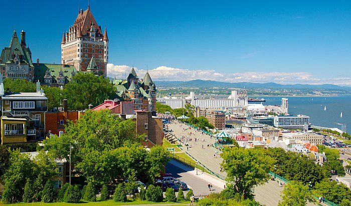
- Montréal, on the banks of the St. Lawrence River, is Québec’s leading metropolitan center and one of Canada’s two largest cities – Toronto is the other. Montréal reflects French culture and traditions.
- Pumpkins are just one of the crops grown in the Niagara “fruit belt.” The mild climate, moderated by the lakes, allows the cultivation of a wide range of fruit and vegetables, including cherries, apples, peaches, grapes, and asparagus. Fruit and vegetable growing is confined to southern Canada due to the northern regions’ colder climate and short growing season.
- Point Pelee is a world-famous site for bird migration. Over 250 species have been sighted on the sandspit, which forms the southern tip of the Canadian mainland.
- The Great Lakes moderate the area’s climate surrounding the St. Lawrence River. Their water, which cools more slowly than the land, acts as a reservoir for warmth, extending the growing season into the early fall.
- Mount Royal, around which the city of Montréal has developed, is the result of an igneous intrusion that occurred between 135 and 65 million years ago.
- In the lowlands around St. Lawrence, earth flows have developed along gentle river banks where sand overlies clay, making the surface layers very unstable. When the slope’s natural equilibrium is disturbed, an earthflow can occur.
Transportation & industry in Southeastern Canada
The cities of southern Québec and Ontario, and their hinterlands, form the heart of the Canadian manufacturing industry. Toronto is Canada’s leading financial center, and Ontario’s motor and aerospace industries have developed around the city. A significant center for nickel mining lies to the north of Toronto. Most of Québec’s industry is located in Montréal, the oldest port in North America. Chemicals, paper manufacture, and the construction of transportation equipment are leading industrial activities.
Using the land & sea in Southeastern Canada
The productive Niagara “fruit belt” on the shores of Lake Erie and Lake Ontario is a central farming region, although available farmland is being challenged by urban expansion. Québec is Canada’s leading producer of maple syrup and dairy products. In the north, farmland gives way to extensive areas of forest, partly used for commercial logging. Fishing occurs in Atlantic waters and the Great Lakes.
Southern Ontario
Formation: 1867.
Southern Ontario is one of the most populous regions in Canada. It borders New York, Michigan, and Pennsylvania. The region is nicknamed “Canada’s High Tech Capital.”
Southern Ontario is the most populated province in Canada and is home to Toronto, Ottawa, and many other cities. The French first settled the area and named it “Le Détroit,” meaning “strait.” Many rivers flow through Southern Ontario, including the Ottawa River, Lake Ontario northward, and the St. Lawrence River southward. The capital city of Southern Ontario is Toronto, with over 2 million people living there. It has a large number of advanced manufacturing facilities and commuter rail systems. There are plenty of opportunities for employment in Southern Ontario.
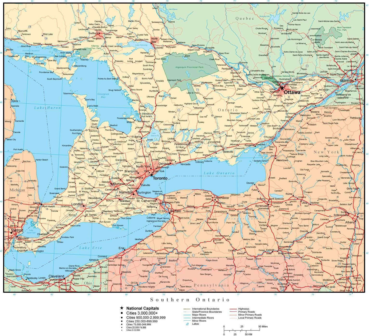
Map of Southern Ontario
Facts about Ontario
- Ontario is the second-largest province in Canada area. It takes up the strip of land on the Canadian mainland between Hudson Bay and James Bay to the north and the St. Lawrence River- Great Lakes chain to the south.
- Ontario is located to the East, South, and West of Quebec, the U.S., and Manitoba. To its, North lies Canada’s second-most populous province of Quebec. It is home to over one-third of Canada’s population.
- Having the country’s most natural resources, Ontario is also a prosperous province with a diverse and already developed industrial economy.
- The Northern and Southern Ontario regions make up the province of Ontario.
- Suppose a line is drawn from the Mattawa and Ottawa rivers, connecting them to the French River on Georgian Bay at the Quebec border. In that case, Northern Ontario usually will be north of this line.
- The Canadian Shield covers 950,000 square kilometers of the region and is characterized by lakes, rivers, bogs, forests, and rocky and rugged terrain.
- The treeline in Ontario is generally low, less than 1500 feet. The exception to this rule is Ishpatina Ridge, the highest point at about 2400 feet.
- The area has some of the wealthiest minerals and resources in all of Canada, which has led to the area’s wealth.
- Southern Ontario contains about 15% of the land area. Most of it is very flat.
- It is the lowest in the Ottawa River area and has its highest elevation point at about 1,770 feet in the Blue Mountains region south of Georgian Bay. The east is separated from the rest of the region by an extension of the Canadian Shield called the Frontenac Axis that crosses the St. Lawrence River east of Kingston and forms various lake districts such as Muskoka Lakes, lakes in Haliburton Highlands, and Rideau Lakes chain which are known best resort areas in Ontario.
- The most dramatic feature of the landscape is the Niagara Escarpment, running roughly northwest from Niagara Falls to the Bruce Peninsula.
- In Southern Ontario, most of the land has rolling plains. However, Eastern Ontario and Western Ontario are both relatively flat.
- The drainage basins of Northern Ontario are split by a higher area running from Lake of the Woods to Kirkland Lake. Major rivers in the northern system are the Severn, Winisk, and Albany, while significant rivers in the southern system include the Ottawa and French.
- Northern Ontario’s climate varies from the Great Lakes area, where frost-free weather is more than 100 days a year, to the Hudson Bay area, where the frost-free period can be as short as 40 days.
- In southern Ontario, there is a bit of variation. There are harsh winters, but the summers are generally warmer than in other regions. Ottawa receives approximately 600mm of snow and 35 degree Celsius in the summertime. The southern part receives less snow throughout the year, but the Ottawa Valley tends to be slightly more relaxed, with about 500mm of snow and 22 degrees Celsius in the summertime.
- Northern Ontario has boreal forests, but a tundra is at the northern extreme. Southern Ontario once had hardwood forests, but lumbering removed most of them during the 19th century.
- Numerous animal species live in Canada, including larger mammals, such as moose, woodland caribou, and black bears. There are also many small animals like porcupines, skunks, and rabbits. There are birds in Canada, including ducks, grouse, and hawks.
Read more and find maps here about Ontario.
Southern Québec
Québec, Canada, is split in two by the St. Lawrence River. The southern part of Québec is sometimes called “Lower Canada,” and it has more French cultural influence. One of the most iconic landmarks in Southern Québec is Montmorency Falls, located on the Niagara Escarpment in Lachute.
Southern Québec is best known for its beautiful mountains, lakes, and rivers. There are plenty of opportunities for those who enjoy winter sports to ski or snowboard. Depending on the area, snowfall can cover ground to 120 centimeters. There are plenty of events throughout the year to mark on your calendar, like the “Snowman Festival” in February, which celebrates our winter traditions with games, contests, and activities for the whole family.
Cities in southern Quebec: Laval (the island just north of Montreal), Longueuil, Magog, Montreal (the city and island of Montreal, just to the south of Laval), Sherbrooke.
The largest city in Southern Québec is its capital city of Montréal.
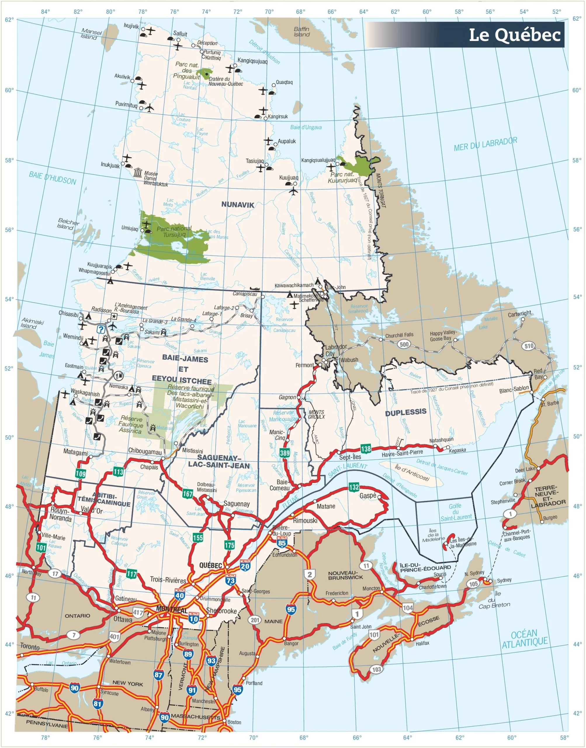
Map of Southern Québec
Facts about Québec
- Quebec is a province in eastern Canada.
- Quebec is the largest Canadian province. It constitutes one-sixth of Canada’s total land area and is second only to Ontario in population.
- Quebec City is the oldest city in Canadian history. It is also called the place where “the river narrows.” Quebec’s name derives from an Algonquin word “where the river narrows.” The city has a fantastic view of the St Lawrence River and Orleans Island.
- Montreal is the largest city in Canada, with an even larger metropolitan area.
- It borders Hudson Strait and Ungava Bay to the north, Newfoundland and Labrador to the east, the Gulf of St. Lawrence, New Brunswick and Maine to the south, New York and Vermont to the west, and Ontario, James Bay, and Hudson Bay on its southwest coast.
- Quebec’s borders have been altered many times since New France was created in the early part of the 17th century. The French colonial empire extended to the Gulf of Mexico and west of the Mississippi River.
- Today, the leadership of Quebec is still trying to resolve their dispute with Canada over the border between Ontario and Quebec.
- Quebec’s territory comprises three distinct physiographic regions, some of which have unique cultural and natural resources.
- Montreal and Quebec City are densely populated, the most populous region along the St. Lawrence River.
- The lowland plain was initially the location of various aboriginal communities, and then Europeans settled there quickly during the early history of New France. The area remains Quebec’s small but vibrant agricultural sector, but it is also home to growing urban communities and a changing industrial economy.
- Quebec’s Appalachian Uplands is the northern extension of the Appalachian Mountains. It stretches from the Gaspé Peninsula to the border of the United States and covers hills, plateaus, and plains. This region also includes Anticosti Island in the Gulf of Saint Lawrence, northwest of Quebec’s Appalachians.
- The Canadian Shield covers most of the land in Quebec and includes the region north of the St. Lawrence Lowlands. This area is rich in natural resources and provides materials for industry.
- 5.4 miles from Mount D’Iberville is the easternmost region of the Torngat Mountains and is 1,652 meters high. It’s the highest peak in Newfoundland and Labrador.
- The Appalachians are the oldest mountain range in the world. The Appalachians start in the Laurentian hills and run north, ending at Ungava Bay.
- The Canadian Shield covers three divisions: the Laurentians, with thousands of lakes and trees; the taiga region, with stunted trees farther north; and the tundra, where the permafrost prevents the growth of trees.
- Quebec has an ample supply of fresh water. It is estimated that Québec’s waters cover about 71,000 km sq.
- The Saint Lawrence River cuts through southern Quebec from west to east and is one of the most vital waterways in North America. The Ottawa, Saguenay, Saint-Maurice, and Manicouagan rivers are among its most essential tributaries which flow into St. Lawrence.
- Extremes of hot and cold often characterize the weather in Quebec. Quebec is affected by major continental air masses sweeping down from the northwest.
- The country’s northeast regions encounter cold Labrador Current, making summers cool. The humid, hot air from the Gulf of Mexico creates heat waves during summer, resulting in abundant winter snowfall.
- From January’s -11 °F to July’s 52 °F (11 °C), Kuujjuaq seems to have a more extreme range of temperatures. A more extensive range of average monthly temperatures; varies from 14 °F in winter to 68 °F in summer. The temperature can change by 30 °F across 24 hours.
- Montreal gets 140 frost-free days per year, while the north has fewer than 80. The south gets 12-13 weeks of snow, while the north gets 23 weeks of snow.
- The climate in Montreal is less severe, so it is greener with wildlife.
Read more and find maps here about Québec.
You may also be interested in the