
Formation: 1949. The origin of the name: Italian seafarer Giovanni Caboto (John Cabot) landed on the island portion of the province on 24 June 1497, on the feast of St. John the Baptist. Cabot called the newfound land “St. John’s Isle” in honor of the saint, but the contraction of “a newfound land” was quickly coined and became the actual name. The name of the mainland portion is believed to come from Portuguese explorer Gaspar Corte-Real who named the area “Terra del Lavrador,” or the farmer’s land. Officially called “Newfoundland and Labrador,” but commonly known simply as Newfoundland.
TIME: 8:30 AM NST = noon GMT; 8 AM AST = noon GMT.
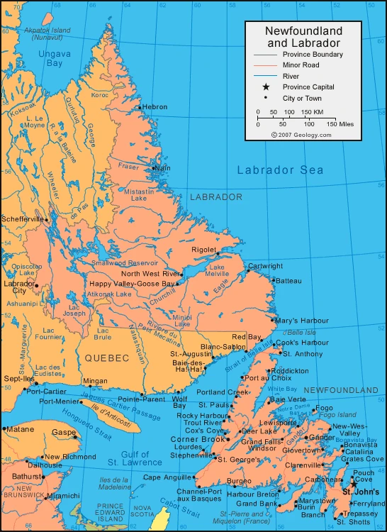
The province of Newfoundland and Labrador covers an area of Canada on the northeastern Atlantic coast. It is a rural region close to the Atlantic Ocean. Gros Morne National Park is a UNESCO World Heritage site in Newfoundland. The park is noted for its geological features, including tablelands with exposed layers of rock and millions of years old caves.
This province has many natural resources, including hydroelectric power, fishing, forests, and minerals. The landscape consists of beautiful coastlines on the Atlantic Ocean, inlets, lakes, and rivers. There are also many hiking trails in Newfoundland and Labrador.
It is a sparsely populated area; most of the population lives on the rugged west coast, where fishing and tourism are important industries. Tourism is also a key industry in Gros Morne National Park in central Newfoundland, which has some of the oldest fossilized trees in the world.
Map of Newfoundland & Labrador
The climate of Newfoundland & Labrador
Newfoundland’s climate is typically a moderate and maritime one. Winter temperatures are surprisingly mild, though it does have high annual rainfall. Labrador’s climate, by comparison, has cold winters and brief summers. St. John’s is Canada’s windiest and foggiest city, while Churchill Falls receives the most snowfall. The temperature ranges for February in St. John’s are 19 to 31°f (-7.4 to -0.6°c), and the temperature ranges in July are 52 to 69°f (11 to 20.5°c). In Happy Valley-Goose Bay, the temperature ranges for February are -8 to 10°f (-22.4 to -12.3°c), and the temperature ranges in July are 50 to 70°f (9.8-21.1°c). Newfoundland’s warmest temperature measured at 41.7°C; however, the coldest was only -51.1°C. A notable thing about Newfoundland is the aurora borealis, which flickered over Labrador during winter.
Facts about Newfoundland & Labrador
- Newfoundland and Labrador is a province in Canada composed of the island of Newfoundland and the mainland of Labrador.
- Newfoundland and Labrador is the newest province, joining the confederation in 1949. The name was officially changed to Newfoundland and Labrador in 2001.
- Newfoundland and Labrador is the most easterly part of North America, and its position on the Atlantic has given it strategic importance in defense, transportation, and communications.
- Labrador and Newfoundland are separated by geography. Labrador is a part of the Appalachian geologic province in North America, and Newfoundland is part of the Appalachian geologic province in North America. As part of the Appalachian geologic province in North America, both are characterized by continental drift, volcanic action, crustal deformation, ice erosion, and deposition.
- The weather of Newfoundland and Labrador changes depending on the season – it is cold but not severe. In July, the mean temperature in Labrador is between 5 and 10 degrees Celsius. The island’s southern coast has temperatures between 15 to 18 degrees Celsius in January, dropping below zero in interior western Labrador.
- Newfoundland’s terrain ranges from thick forests to coastal regions with few trees. The most common tree species are conifers, with balsam fir and black spruce being the most abundant.
- Moose, introduced to Newfoundland in the early 20th century, is now the most plentiful of the large wild mammals on the island. They outnumber woodland caribou in Newfoundland and live mostly in northern Labrador. Other species include black and polar bears, Arctic and red foxes, beaver, lynx, and smaller animals that live in northern Labrador’s tundra or coniferous forests. There are many seals on Newfoundland’s coastlines for people to see.
- The majority of the people of Newfoundland are white, but some minority races also exist. Inuit and Innu people occupy a few settlements in Labrador, retaining their original language and a portion of their ancient culture.
Google Maps of Newfoundland & Labrador
Visit this page for driving directions in Canada.