
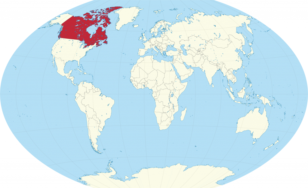
The official name of the country: is Canada, located in North America
Formation: 1867 / 1949
Independence: July 1, 1867, from the United Kingdom
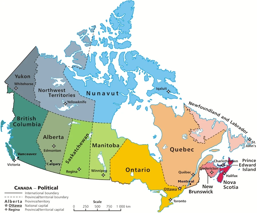
Capital city: Ottawa
Major Cities: Vancouver, Calgary, Toronto, Ottawa, Montréal, Québec City, Halifax
Population: In 2021/2022, Canada’s population grew by a record 703,404 people (+1.8%) to reach an estimated 38,929,902 on July 1, 2022. This surpassed the preceding high observed a year before the COVID-19 pandemic (2018/2019) when the population grew by 536,146 people (+1.4%).
Total land area: 9,984,670 square km (3,855,171 square miles)
Coastline: 243,791 kilometers (151,485 miles)
Climate: Varies from temperate in the South to subarctic and arctic in the North.
Spoken languages: English (official), French (official), Chinese, Italian, German, Ukrainian, Portuguese, Inuktitut, Cree
Provinces (10): British Columbia, Alberta, Saskatchewan, Manitoba, Ontario, Québec, New Brunswick, Nova Scotia, Newfoundland, Prince Edward Island
Territories (3): Yukon, the Northwest Territories, Nunavut
Religions: Roman Catholic, 46 percent; Protestant, 36 percent; other, 18 percent
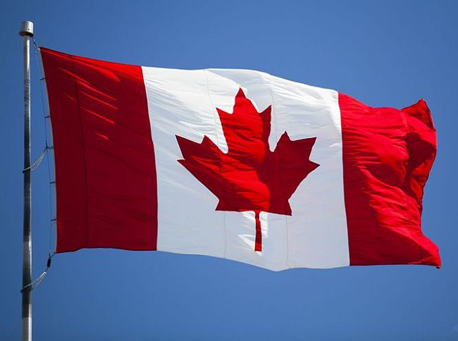
National Anthem: “O Canada”
Ethnic mix: European 87%, Asian 9%, Amerindian, Métis, and Inuit 4%
Government: Confederation with parliamentary democracy; Parliament consists of two houses: a 301-member House of Commons, whose members are elected by the people, and a 104-member Senate, whose members are appointed by recommendation of the Prime Minister
Head of Government: Prime Minister
Chief of State: British Crown, represented in Canada by the Governor General
Cabinet: Panel of ministers appointed by the Prime Minister from members of the majority party in Parliament
Voting Rights: All Canadian citizens over the age of 18 can vote
Currency: Canadian dollar = 100 cents
Literacy rate: 99%
Average daily calorie consumption: 3530 kilocalories.
Holidays: New Year’s Day, January 1; Good Friday; Easter Monday; Victoria Day, the Monday preceding May 25; Canada Day, July 1; Labor Day, 1st Monday in September; Thanksgiving Day, 2d Monday in October; Remembrance Day, November 11; Christmas Day, December 25; Boxing Day, December 26. Other holidays are observed in some provinces.
Monetary unit: The Canadian dollar (c$) is a paper currency of 100 cents. There are coins of 1, 5, 10, 25, 50 cents, and 1 dollar, and notes of 2, 5, 10, 20, 50, 100, and 1,000 Canadian dollars. Silver coins of 5 and 10 dollars, commemorating the Olympics, were issued during 1973–76. C$1 = US$0.6899 (or us$1 = c$1.45) as of May 2003. US currency is usually accepted, especially in major cities and borders.
Time: Newfoundland, 8:30 AM = noon GMT; New Brunswick, Nova Scotia, Prince Edward Island, and Québec, 8 AM = noon GMT; Ontario east of 90° and western Québec, 7 AM = noon GMT; western Ontario and Manitoba, 6 AM = noon GMT; Alberta and Saskatchewan, 5 AM = noon GMT; British Columbia and Yukon Territory, 4 AM = noon GMT.
Weights and measures: The metric system is the legal standard.
Location and size: Canada consists of the North American continent north of the US, excluding Alaska and the French islands of St. Pierre and Miquelon. Canada is slightly larger than China and the United States, it has a total boundary length of 131,099 miles (210,973 kilometers), and its capital city is Ottawa.
Canada’s land area is almost 4 million square miles (nearly 10 million square kilometers). The United States–Canadian border stretches for 5,524 miles (8,890 kilometers), and some southern portions of Canada dip below the more northern United States cities. Canada’s three other borders are bounded by oceans, holding land ranging from ice-topped mountains to fertile farmland.
Land Use: Forests and woodland: 54 percent Arable land: 7 percent Other: 39 percent.
Major Rivers: St. Lawrence, Mackenzie, Yukon, Fraser, Red.
Natural Resources: Minerals, fish, timber, coal, petroleum, natural gas, hydropower. Read more about the natural resources in Canada here.
Map of Canada
Canada is the second-largest country globally, and with only about one-tenth of its land area, it is one of the most sparsely populated. The total surface area of Canada is only 510 million km2. That’s less than two percent of the Earth’s surface. Canada occupies 6.1% of the Earth’s land and is 148.9 million km2. Without their lakes, Canada would be smaller than the USA. The United States has a greater land area than Canada, but not when you factor in its lack of water mass.
Canada became a confederation in 1867, though Newfoundland did not join until 1949. As a founding member of the UN and the Commonwealth, Canada has played an essential role in international affairs.
Despite its size, Canada is sparsely populated and has an incredible landscape. As a result, it has an identity that stems from the wilderness. In 1837, Irish-born writer Anna Brownell Jameson explored Ontario and said in a triumphant tone, “the seemingly endless line of trees before you; the boundless wilderness around you; the mysterious depths amid the multitudinous foliage, where the foot of man hath never penetrated…the solitude in which we proceeded mile after mile, no human being, no human dwelling within sight”.
Canadians are few, but they have the quality of a model multicultural society by welcoming immigrants from other countries and natural resources that can be found nowhere else.
Canada is officially bilingual and holds its history as ground once contested by two of Europe’s great powers. Canada is derived from the Huron-Iroquois Kanata, meaning a village or settlement. The name was used in the 16th century to refer to the area around the settlement that would become Quebec City. After Britain conquered New France, Quebec was sometimes used instead of Canada. The name was fully restored and holding its history as ground once contested by two of Europe’s great power after Canada became entirely self-governing within the British Empire in 1931.
With no military force posted on the border, Canada shares the longest border with the United States. Most of its population lives within 185 miles of the border. The countries share many similarities, but their differences are also profound.
A constitutional crisis focused on the French-speaking Québécois, Inuit, and Native American land rights dominated politics in the 1990s. In 1999, part of the Northwest Territories, Nunavut, became a self-governing homeland.
Canada has memberships in the Commonwealth and was a leader of La Francophonie. They were also a part of the UN and contributed to many UN agencies. Canada is currently part of the Free Trade Agreement with the US, superseded by NAFTA.
Canada was a founding member of the Organization for Economic Co-operation and Development and is part of the Group of Seven.
The national capital is Ottawa, Canada’s fourth-largest city. It lies some 250 miles northeast of Toronto and 125 miles west of Montreal. In population, these are Canada’s first and second cities. The third-largest city is Vancouver, which does business with countries on the Pacific Rim, and is the principal western gateway to Canada’s developing interior. Other major metropolitan areas include Calgary and Edmonton in Alberta, Quebec City in Quebec, and Winnipeg in Manitoba.
Natural Geography
The northern and central parts of the country are covered by lake country; the surface is gently undulating and very rich in rivers. The Prairie Plateau in the southwest and the Appalachian Mountains in the southeast. The Rocky Mountains and the Coastal Mountains are a range of deep valleys to the west.
Highest point: Mount Logan, 5,959 meters (19,551 feet)
Significant rivers include the St. Lawrence River, Peace, Mackenzie, Churchill, Nelson, Columbia, Athabasca, and Yukon.
Largest lakes: Great Bear Lake, Great Slave Lake, Lake Winnipeg, Lake Winnipegosis, Upper Lake, Lake Huron, Lake Ontario, Lake Athabasca, Reindeer Lake, and Lake Erie.
Canada has an extensive border, including thousands of islands and land in all 8 provinces. Canada borders The Arctic Ocean, another country’s Greenland to the northeast, and The United States to the south and west.
Canada is one of the most critical topics in Canada’s geography as it ranges from 52° to 141° W and 42° to 83° N. While Canada is often only considered a far north country, the southernmost point of Ontario lies at the same latitude as northern California. As a result, many international commercial flights fly through Canada.
Provinces in Canada are divided into regions, which often overlap. Contiguous provinces can be grouped to form a region even if they reside near the Atlantic Ocean. Not including Newfoundland and Labrador, the Maritime Provinces are often designated “Maritime” and Quebec, Ontario, and these three provinces are sometimes referred to as “Central Canada”. Western Canada typically means Alberta, Saskatchewan, Manitoba, and British Columbia but may refer to these provinces collectively as “Prairie Provinces” or Prairie. Yukon is regarded as part of Western Canada and so are northwestern territories.
Canada has a diverse geography, with high mountains on the border and a hilly interior. It is more mountainous in the west than in the east, and Canada’s characteristic landscape is one of the small low-rolling hills.
Canadians created a large country by linking the east-west US and Canada, using transportation and communication links that go against the grain of the continent. The Canadian North remains one of the least settled and economically exploited parts of the world.
Canada can be divided into six physiographic regions: the Canadian Shield, the Interior plains, and the Great Lakes-St. Lawrence lowlands, the Appalachian region, the Western Cordillera, and the Arctic Archipelago.
The Canadian Shield is the country’s largest region, occupying about half of the total area. The mountain-building events and erosion gradually cut down until it reduced to a mostly flat, nearly featureless plain. The rim of the shield is warped and folded. Along the St. Lawrence River shore, Quebec and Ontario’s shields are about 2,000 feet (600 meters) in height. In Manitoba and northwestern Ontario, lakes dot the perimeter of the shield edge. The Hudson Bay Lowlands lie at elevations below 2000 feet. As a result, most of the shield contains monotonous landscapes with little to no variation in topography. Glaciers, however, have drastically affected the surface of the area. Glaciers could move and roughen these surfaces without an amorphous top layer of rock and soil. This erosion process left loose “rock knob” hills with hollows or troughs between ridges usually covered in lakes. Glaciers drop till or moraine deposits in other areas and dash across the surface in long erratics that stretch over 100 miles. Here, depositions from old sub-glacial streams give way to clay deposits that are now exposed to air due to a lack of water. The Hudson Bay Lowlands also contain many minerals (such as coal, silver, gold, and nickel), making it an excellent place for mining activity.
The lowlands in Canada are composed of sedimentary rocks. The three largest lakes found in Canada, Great Slave, Great Bear, and Lake Winnipeg, are all located along the boundary of the shield-interior plain.
The Manitoba Lowland region is the flattest land in the interior plains. It is underlaid by the lacustrine sediments of Glacial Lake Agassiz and is located in the SE part of Canada. The lowlands are known for their fertile soil, black clay, and silt in the south, covered by Lake Winnipeg, Lake Manitoba, and Lake Winnipegosis.
The Manitoba lowland is located east of the scene depicted in this painting and has an elevation range of 1,500 to 2,100 feet. The Saskatchewan plain is visible on the right side of the image, and the Alberta plain can be seen on the left side. These plains are rolling landscapes with glacial deposits laid over almost horizontal bedrock. Hiking trails cut through these green hills and valleys with vast water bodies created by glaciers. There are flat plains there also. Large potash deposits characterize Alberta. Large coal, oil, and natural gas reserves are located in Cypress Hills in Saskatchewan and Alberta. The Mackenzie lowlands, extending from the Alberta plains north to the Arctic Ocean, is an area covered in muskegs and swamps that the Mackenzie River drains.
The Great Lakes-St. Lawrence region encompasses the southern Ontario area bounded by a Canadian Shield and three lakes (Huron, Erie, and Ontario). Although relatively minor, the region extends along the Saint Lawrence River to the Atlantic ocean. Despite its small size, this region’s high agricultural productivity, intensive industrialization, and urbanization levels make for a crucial area.
The Great Lakes region is notoriously fertile, with highly cultivated forests and rolling hills of glacial landforms. In southwestern Ontario, the Niagara Escarpment is the only prominent bedrock structure that runs through Niagara Falls to Georgian Bay. This stretches from the Ottawa Valley into Manitoulin Island.
North of the Frontenac Axis, this lowland area extends into the Ottawa and St. Lawrence valley, nearly as far as Quebec City. This was inundated by seawater during a glacial period, and it has left a very flat plain. The Monteregian Hills interrupt this otherwise level landmass – the last of them being the Mont-Royal in Montreal, which is about 820 feet high.
Appalachia is a region that includes the Eastern townships of Canada and stretches northeastward to the Gaspé Peninsula and the Maritime Provinces. This region’s ancient rock formations eroded into low, rounded mountains dissected by valleys, interrupted by lowland areas developed on weaker rock formations. The highest mountain in southern Quebec is about 4,000 feet (1,200 meters). The hills have also been dissected from north-central New Brunswick and Nova Scotia. There are more dissected highlands than lowlands in Newfoundland, with the inland part of Newfoundland being plateau upland. Along the coast of Newfoundland’s west side, there is a range of high mountains called the Long Range Mountains, approximately 2,000 feet in elevation.
The Cordillera region, which spans from Canada to Northern Mexico, comprises mountain ranges. Many of these are very young, and some are still active. Valleys have deep glacial activity in some areas, with snow-capped and sharp peaks. The view from an overhead perspective shows the entire landscape as a series of mountain ranges that run south-north.
The eastern portion is shared between Canada and the US in the Rocky Mountains. This area holds some of North America’s most rugged and picturesque landscapes. More than 30 peaks in this mountain range exceed 10,000 feet, including Mount Robson, which rises to 12,972 feet. There are national parks like Banff in Canada, established in 1885. Three significant passes also cut through these mountains: Yellowhead, Kicking Horse, and Crowsnest Pass. The Trans-Canada Highway is routed through Kicking Horse Pass.
The Rocky Mountain Trench is the valley in the West of the Canadian Rockies, and from there, there are mountains to both its East and West. They then continue their range north until they run into the Coast Mountains. These mountains are steep, snowy, and full of diverse wildlife.
The Saint Elias Mountain group is home to Canada’s highest peak, Mount Logan. On the coast, the region is a series of cliffs rising over 7,000 feet from the water. The area is a significant lead, zinc, copper, and gold source. Eastern fringes contain coal deposits.
The Arctic Archipelago comprises thousands of islands north of the Canadian mainland. The southeastern islands are an extension of the Canadian Shield. There are two distinct landform regions for the balance: The Arctic lowlands to the south and the mountains of the Innuitian Region to the North. The Innuitian ranges are geologically young mountains similar to Western Cordillera, with some peaks and ridges reaching 10,000 feet (3,000 meters). For much of the Innuitian Region, snow and ice cover most parts permanently covered with snow. There are also parts where mountaintops occasionally protrude when exposed to direct sunlight.
National economy and role in the world economy
Chief Exports: Wheat and other agricultural products, newsprint, wood pulp, lumber, petroleum, natural gas, metals, telecommunications equipment, motor vehicles and parts, manufactured goods, and hydroelectricity.
Major Economic Partners: United States, Japan, and the United Kingdom.
One of the wealthiest and most developed countries on Earth. Its development has been based on its rich natural resources, especially its vast land area, fish, fur, timber, and mineral wealth. Although agriculture has declined in importance in its economy, it remains the most crucial sector in many regions. It is a significant exporter of agricultural products due to its significant production and low population. It is one of the largest wheat producers globally and has a significant production of vegetables, fruit, maize, tobacco, and soya. Livestock and fisheries are also prominent. Forestry continues to be an important sector of the rural economy. The mining of nickel, platinum, gold, uranium, copper, titanium, cobalt, molybdenum, petroleum, natural gas, coal, and iron ore is also significant globally. Its petroleum reserves are the third-largest after Venezuela and Saudi Arabia (highlighted by the vast oil sands in the province of Alberta). The country’s advanced metallurgy is based on its mineral resources and cheap energy. The country’s manufacturing industry is dominated by chemicals, wood, machinery, and transport equipment (the latter accounting for nearly a quarter of exports, with the US and Japanese automotive companies accounting for a significant share).
The 1989 Free Trade Agreement with the US and the 1994 North American Free Trade Agreement (NAFTA) have significantly increased trade with the US and Mexico. The economy grew moderately between 1993 and 2007, with a 2.5% decline in 2009 due to the global economic crisis, but has grown again since 2010, at 2-3%.
Main exports: transport equipment, machinery, chemicals, timber, lumber, crude oil, natural gas, aluminum, and electricity.
Imports are dominated by various consumer durables, machinery equipment, and textiles. The USA is its most important partner, accounting for 3/4 of its exports and half of its imports. Other important trading partners are China and Mexico. Foreign capital investment plays a vital role in the country’s economy. Most of this comes from the US (in manufacturing, mining, and services), but there are also European (German, French, British) and Japanese investors. However, the country also participates as an investor in international capital flows, with total working capital worth USD 1,130 billion.
Transportation and industry of Canada
Abundant energy in coal, oil, natural gas, and hydroelectric power underpins the Canadian industry. Over 75% of the manufacturing is concentrated in the Great Lakes-St. Lawrence region, including prospering aerospace, transportation, and hi-tech industries. Across Canada, manufacturing has developed around a diversified, high-quality resource base and a wide range of metallic and nonmetallic minerals.
Using the land and sea
Most of Canada’s agricultural land is in the prairies, covering 140 million acres (57 million ha) and supporting wheat and grain-fed cattle. More specialized crops, such as fruit and vegetables, are grown in pockets of agricultural land in the east and west. Of Canada’s many islands, only Prince Edward Island has notable farmland. Further north, boreal forests, exploited for timber, run in an almost unbroken arc, giving way to uncultivable tundra and ice sheets in the far North.
The landscape of Canada
The massive Rocky Mountains form a continental divide between eastward and westward rivers. The interior plains lie east of the mountains, stretching from the Arctic Circle south into the US. Covered with glacial deposits from the last Ice Age, these are interspersed with hilly regions and long, steep escarpments.
Capital cities of Canada
| Province/Territory | Capital City |
| Canada | Ottawa |
| Newfoundland & Labrador | St. John’s |
| Prince Edward Island | Charlottetown |
| Nova Scotia | Halifax |
| New Brunswick | Fredericton |
| Quebec | Quebec City |
| Ontario | Toronto |
| Manitoba | Winnipeg |
| Saskatchewan | Regina |
| Alberta | Edmonton |
| British Columbia | Victoria |
| Yukon | Whitehorse |
| North West Territories | Yellowknife |
| Nunavut | Iqaluit |
Interesting facts about Canada
- Mount Logan rises 5959 m (19,551 ft). It is the highest peak in Canada.
- The Columbia Icefield in the Rocky Mountains is the source of two major rivers, the Athabasca and the North Saskatchewan.
- The badlands of Alberta were created when east-flowing rivers, swollen by meltwater at the end of the last Ice Age, cut deep, vast canyons producing eroded, barren landscapes.
- The Nelson and Churchill rivers drain northward across the Canadian Shield to Hudson Bay. The shield covers three-fifths of Saskatchewan.
- The Rocky Mountain Trench is the longest linear fault in the world. It has formed a straight, flat-bottomed valley between 4–15 km (2–9 miles) wide and up to 1000 m (3280 ft) deep.
- Hundreds of islands dot the fjord-indented coast of British Columbia; the largest is Vancouver Island.
- Three significant passes cut through the Rocky Mountains: Yellowhead, Kicking Horse, and Crowsnest. They are all used as transportation routes through the mountains.
- The Cypress Hills rise to 1465 m (4806 ft) above the surrounding plain. Having escaped the last glaciation, they contain unique plant and animal life. The silvery lupine, bunchberry, and lodgepole pine all grow in the cool, moist climate of the hills.
- The Alberta and Saskatchewan plains bear strong testament to past glaciations. The Assiniboine, Saskatchewan, and Qu’Appelle rivers occupy flat-bottomed, steep-sided valleys eroded by glacial meltwater during the last Ice Age.
- The lowlands of Manitoba are a basin that once held the vast post-glacial Lake Agassiz, remnants of which include Lake Winnipeg, Lake Winnipegosis, and Lake Manitoba.
- The Nelson and Churchill rivers drain northward across the Canadian Shield to Hudson Bay. The shield covers three-fifths of Saskatchewan.
- Across the tundra of northern Manitoba, widespread permafrost inhibits water from permeating the soil. This causes rivers like the Churchill to flow in many channels, frozen for up to six months during the winter.
- Ancient granite outcrops, part of the Canadian Shield, rise above the surface of Setting Lake, which was initially formed by meltwater from the last Ice Age.
You may also be interested in the