
Formation: 1873. The origin of the name: Prince Edward Island was initially called Abegweit (“lying down flat, or “cradled by the waves”) by the Micmac Indians. Europeans called it the Island of Saint John in 1763; in 1799, the Island was renamed Prince Edward Island in honor of Prince Edward of England.
TIME: 8 AM AST = noon GMT.
Prince Edward Island, a Canadian province and the smallest in the country is located on a large island off the east coast of Canada. Its mild weather, sandy beaches, and beautiful scenery are called “Canada’s Summer Playground.” The Island has one city of any significant size (Charlottetown, home to many historic buildings and museums) and relies heavily on seasonal industries such as lobster fishing and farming. Residents are mainly English-speaking, with French minority speakers in some rural areas.
Prince Edward Island is a Canadian province with a population of about 140,000. It is located in the Gulf of Saint Lawrence, along the eastern seaboard in Canada. The Island was named after Prince Edward Augustus, the Duke of Kent.
The Island includes several communities, towns, and villages scattered across its landscape. The population density is 42 people per sq km, meaning it’s one of Canada’s least densely populated places. Tourists have many natural attractions, such as sandstone cliffs, beaches, and clear blue waters.
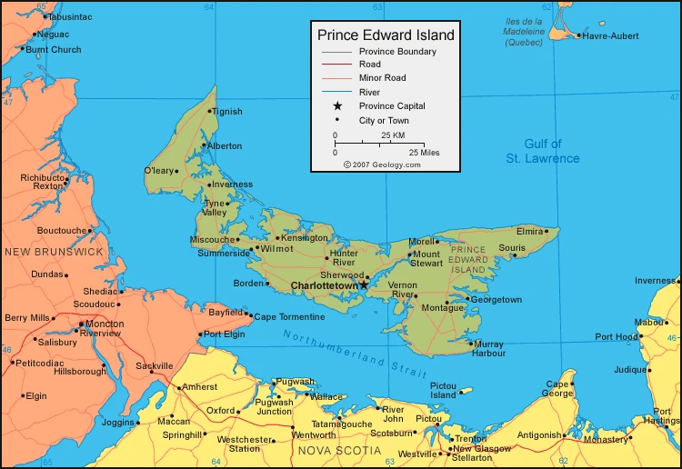
Map of Prince Edward Island
The climate of Prince Edward Island
Generally speaking, the climate is temperate and most rainy around November through January. You can expect an average temperature of 19°F (-7°C) in January and 64°F (18°C) in July. The highest recorded temperature in Charlottetown is 98°F (36.7°C), which occurred on 1 August 1935, and the lowest recorded temperature was -35°F (-37.2°C). This temperature occurred on 26 January 1884 at Kilmahumaig.
The climate of Prince Edward Island is a moderate maritime one, which means the temperatures are milder than inland. This is due to the warm Gulf waters from the Gulf of St. Lawrence, which are between 25-30 C (77-86 F) all year round. The climate has changeable weather throughout the year – there is no set day-to-day weather for it, and that’s what makes it so unpredictable.
Every year, the PEI average daytime high is 0°C (32°F) in January and 23 °C (73 °F) degrees Celsius in July. The Island receives an average rainfall of 855 millimeters (33.71 inches) and a yearly snowfall of 2,850 millimeters (112 inches).
Winters are cool and long but are less cold than locations farther inland. When Arctic air and Atlantic air clash, the result is often a drastic temperature change. This moderating effect is eliminated when the Gulf of St. Lawrence freezes over, so storms during the winter are more common than elsewhere during the year. The average temperature in January is −7 °C (19 °F). Spring arrives when most of the sea ice has melted, usually in late April or early May.
The summer months are sometimes quite warm, with the maximum daily temperature rarely exceeding 30 degrees Celsius (86 Fahrenheit). Fall is a pleasant season because the Gulf waters keep it from getting too cold at first. However, winter brings higher storm activity than summer. There is still plenty of precipitation throughout the year, although it is heaviest late in the fall, early in the winter, and in mid-spring.
Google Maps of Prince Edward Island
Prince Edward Island is the smallest Canadian province in land area and population but is the most densely populated. It is located in the Gulf of St. Lawrence, about 200 kilometers north of Halifax and 600 kilometers east of Quebec City. Farming is the backbone of the island economy; it produces 25% of Canada’s potatoes. Other important industries include fisheries, tourism, aerospace, bio-science, IT, and renewable energy.
Geography
Prince Edward Island is located in the Gulf of St. Lawrence and sits directly east of New Brunswick. The Northumberland Strait borders it on its southern shoreline, and its two major urban areas are Charlottetown and Summerside. The province has a population density that ranks Canada’s highest, with an estimated total population for 2016 of 141,766.
The larger urban area is situated on the southern shore of Prince Edward Island, just outside of Charlottetown. It contains the capital city Charlottetown, suburban municipalities Cornwall and Stratford, and a growing urban fringe. The much smaller urban area developed around Summerside Harbour on the southern shore 40 km outside of Charlottetown Harbour and consisted primarily of the city of Summerside. As with all natural harbors on the Island, Charlottetown and Summerside harbors are created by rias.
The coast has various climates, including long beaches, sandstone cliffs, saltwater marshes, and many bays and harbors. The beaches, dunes, and other rocks are made from sedimentary material with a high iron content which turns an oxidized red when exposed to the air. The song-like sound the sand will make when walked on is specific to an area in Basin Head: it consists of silk there, and only in this area does it produce this unusual noise. Large dune fields can be found on barrier islands at entrances for bays and harbors. Greenwich Dune Fields are especially significant due to the rare plants and archaeology that can be found nearby.
The shifting, parabolic dune system is home to a variety of rare birds as well as many different types of plants; it also holds much archaeological significance due to its site of unique items from the past.
Facts about Prince Edward Island
- Prince Edward Island is one of the Maritime Provinces in Canada.
- Prince Edward Island is around 225 kilometers long and ranges from 3 to 65 kilometers in width.
- It is located at the coordinates of 46°-47° N latitude and 62°-64° W longitude. The Northumberland Strait is south, separating the Island from Nova Scotia and New Brunswick.
- It is nicknamed the “Garden of the Gulf” and the “Million Acre Farm”. It is sometimes referred to as “Spud Island” because of its potato production.
- The shoreline features many bays and estuaries. Dunes generally block these on the north side, but there are good natural harbors on the south and west. The average height of the red sandstone cliffs is 20 feet (6 meters), but some rise to 50 feet (15 meters).
- There are hills in central Queens county and level stretches in western Prince county. Queens County has the highest elevation of 466 feet (142 meters) above sea level.
- The ocean dramatically influences the climate of Prince Edward Island. It often experiences a delay in weather changes and can be significantly impacted by the ocean’s temperature.
- The average mean temperatures year-round are around 40 degrees Fahrenheit, but extreme fluctuation remains.
Visit this page for driving directions in Canada.