
Formation: 1999. The origin of the name is Inuktitut, which means “our land.”
8 AM AST = noon GMT; 7 AM EST = noon GMT; 6 AM CST = noon GMT; 5 AM MST = noon GMT.
Nunavut is a Canadian territory, which also can be referred to as the Arctic region. It was created in 1999 in the eastern half of the Northwest Territories. Nunavut encompasses the Indigenous peoples’ traditional lands of the Arctic, the Inuit people. Their language is called Inuktitut, and it means “Our land.” At the head of Frobisher Bay, the capital is Iqaluit on southern Baffin Island.
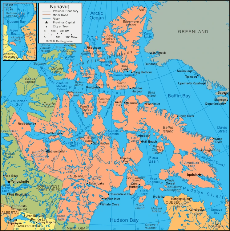
The Arctic Ocean is to Nunavut’s north, Greenland is to its east, and Quebec touches it on the southeast from Hudson Strait and Hudson Bay. In addition, it shares a land boundary with Manitoba on its south and the Northwest Territories on the southwest and west. The Nunavut territory had a population of 36,858 people in 2021 and covers an area of 808,185 square miles and 2,093,190 square km. This territory constitutes the more significant part of Canada’s Arctic Archipelago and its largest island, Baffin Island.
Map of Nunavut
Nunavut is divided into the Canadian Shield and the Arctic Archipelago. The Canadian Shield has poorly drained lowlands, and the Arctic Archipelago comprises islands in Hudson Bay. There are tens of thousands of lakes in the Arctic caused by glaciers. The Arctic Archipelago is at the south, rises to the Innuitian Mountains, and slopes up along the eastern side of Baffin Island. Barbeau Peak is the area’s highest point, reaching 2,616 meters / 8,583 feet high. This area is covered by snow and ice, especially in the north.
Temperatures are very, very cold in Canada. The average January temperatures rise above −22 °F (-30 °C) only on the eastern coast, and even then, they don’t get any warmer than -31 °F (-35 °C). Some places in Canada have never seen temperatures over 50 °F (10 °C), and in the winter, it can dip down to as low as -22 °F (30 °C). Very little rain is throughout most of the territory, and it only falls as snow. The more significant precipitation is located on Bylot Island, with rain levels higher than 600 mm. There’s continuous permafrost under the entire territory.
The Canadian territory of Nunavut is located above the northern limit of tree growth. The timberline – running northwest-southeast just within the Northwest Territories – is traditionally considered the boundary between two cultural areas: the Inuit to the north and American Indian tribes, known as Dene, to the south. Tundra vegetation, including lichens, mosses, flowers, and small shrubs, lies above the timberline. Plantlife includes small mammals, caribou, and musk oxen. The animal population comprises red and Arctic foxes, wolves, grizzly bears, seals, walruses, and polar bears. Rare animals include beluga whales and narwhals, who inhabit the coastal waters. The tundra has a few year-round residents, such as the snowy owl and the gyrfalcon. But few birds live there due to the bad climate during the summer months – pesky mosquitoes and other biting insects are much more prominent.
The Inuit people represent the majority of Nunavut’s population. Nearly all of the other residents are of European descent. The Inuit language comprised several different dialect groups and was initially written in both Roman letters and a syllabic system created by a missionary. Nunavut is a territory in northern Canada, and the government recognizes four languages spoken there as official: Inuktitut, English, French, and an Inuktitut dialect spoken in western Nunavut.
The origins of the Inuit are obscure, but people have lived in the Canadian Arctic Archipelago for more than 4,000 years. They arrived about 1,000 years ago in what is now Nunavut. Europeans did not come into contact with them until the late 18th century. The Inuit relied on trapping or hunting for food or clothes; they lived in igloos and tents made from animal skin to protect them from the harsh elements.
The fur trade wasn’t well established in the Arctic until 1920. However, the Inuit assimilated to it quickly. The population declined during the 19th century due to disease and after WWII construction, which further affected their way of life. Until 1950, the Canadian government enforced assimilation to encourage settling down.
Nunavut is among the most sparsely populated regions on Earth. In addition, settlements are tiny and are clustered mainly in coastal areas. The largest town, Iqaluit, is also the administrative and cultural center of the territory. A few other towns, including Rankin Inlet (Kangiqting), located along the northwest coast of Hudson Bay, and Pangnirtung (Panniqtuq) on the Cumberland Peninsula Baffin Island. Alert, a weather station and military outpost in North America’s northernmost point, is arguably one of the most remote communities in North America due to its position on Ellesmere Island.
In the Arctic, where the population is rapidly growing because of high rates of natural increase, for every 10 people over age 65, there are 15 people below age 15. In its demographics, Canada’s Arctic territory looks very different than its other regions.
The people of Nunavut have a lot to rely on. They enjoy the benefits of their mineral wealth, including iron and nonferrous ores, precious metals and diamonds, petroleum, and natural gas. However, accessing the resources is limited by high costs and transportation difficulties. The federal government has contributed to resource development by promoting infrastructure and supporting mining ventures. In addition, the government typically invests in and develops applicable industries that employ many people from within the territory. The government and its agencies are a vital source of income and employment for the region.
Inuit communities in the eastern Arctic fish and export these species to southern markets. Some still perform traditional activities of trapping small mammals, fishing, and hunting sea mammals. The skins are sold to commercial garment makers, and sport fishing draws tourists.
Mining is the most significant economic sector in Nunavut. Lead and zinc mining was practiced on Little Cornwallis Island until reserves were depleted in 2002. Gold deposits have been worked on the mainland at Contwoyto Lake, southwest of Bathurst Inlet. Diamonds have also been sourced from Ikaluktutiak, 220 miles (350 km) southeast of Cambridge Bay (Nunatsiavut). Significant yet untapped oil and natural gas reserves are present here as well.
History
This portion of the article covers what is now Nunavut from the late 20th century to the present. For earlier history of the region, see Northwest Territories.
Inuit in the Canadian Arctic region have lived a nomadic lifestyle, hunting, fishing, and trapping. However, by the mid-20th century, most had transitioned to living in communities where they received support from welfare programs. Improvements in nutrition and health care were accompanied by severe social problems related to substance abuse, unemployment, and crime. The Inuit, seeking greater control over resource management and other areas of the administration of their affairs, intensified pressure on the federal government. They first began negotiating for land claims in the mid-1970s. In 1992, a referendum in the Northwest Territories approved the division of the territories; as a result, representatives of the federal government and Inuit reached an agreement. The first act passed was the Nunavut Land Claims Agreement Act, which settled the Inuits’ land claims against the government after giving them 375,000 square kilometers / 135,000 square miles of territory. The second act introduced a new territory bearing its name, Nunavut, in 1999.
With mixed outcomes, the ethnic-based territorial government experiment in Nunavut started. Despite the economic growth and increased pride, insecurity and social problems arose amongst the young natives of North America. Elders, government officials, and the natives have continued to work towards resolving these issues since the 21st century.
Facts about Nunavut
- On April 1, 1999, the Northwest Territories (NWT) was created. This marked the first significant change in the maps of Canada since Newfoundland joined the Confederation in 1949.
- The motivation for creating two new territories in Canada’s North came from the people of Nunavut’s desire to have their own government, one that is closer to the people and culturally based, including the use of Inuktitut as the working language of the new government.
- In 1966, the federal government appointed Dean A.W.R. Carrothers to head up a commission to study government development in the Northwest Territories. After completing this study, the Commission recommended that the NWT not divide into two territories, which slowed discussions on the issue for a few years.
- In 1976, the issue was re-ignited when the Inuit Tapirisat of Canada (the leading political Inuit organization) proposed the creation of Nunavut as part of the comprehensive Inuit land claim settlement. Later that year, due to development pressure in their region, the Inuvialuit split from the ITC and pursued their land claim.
- In 1979, the Federal Electoral Boundary Commission proposed two new districts for the Northwest Territories. They came into effect in time for that election.
- Over the next 12 months, many groups laid boundaries on where a dividing line could be drawn if the Northwest Territories split up into three. The Dene Nation suggested that there should be three territories instead of one. However, the Métis Association recommended expanding the Manitoba/Saskatchewan boundary northward. The Inuit Land Claims Commission recommended a new territory and government called Nunavut in 1977.
- Despite not having a concrete consensus, members of the Legislative Assembly voted 16-1 in favor of creating two new territories.
- In 1982, MLAs agreed to put the division question to voters of the NWT, asking whether they wanted their territory divided. The referendum on dividing the NWT was held on April 14, 1982, and 56.6 percent of voters supported the idea; voting in Nunavut was very high support. Over the next 10 years, federal officials announced their support for Nunavut, boundaries were agreed to and then disagreed upon, and a boundary referendum was called and canceled. In 1992, the Executive Council set May 4 as the date for Northerners to vote on a proposed boundary known as the Parker line for creating two nations from one territory: a slim majority of 52 percent supported it – with higher voter turnout among Inuit in Nunavut than West.
- In November 1992, the Inuit overwhelmingly approved the Nunavut Final Land Claim Agreement to fulfill their vision of creating Nunavut and their government, with leaders of Canada agreeing on how to implement the deal. This Land Claim was signed by Prime Minister Brian Mulroney in May 1993 and replaced the Tunngavik Federation of Nunavut as it negotiated the claim.
- The Legislative Assembly and the Government of the Northwest Territories (1995-1999) were responsible for the overwhelming task of establishing two new territories. Some tasks included passing legislation to create the new territories and transferring responsibility for programs and services to the new Nunavut Government in time for April 1, 1999.
Google Maps of Nunavut
As visualized through Google Maps, Nunavut offers a unique perspective on this vast and remote Canadian territory. Here are some fascinating facts that link the features of Google Maps with the distinct characteristics of Nunavut:
- Extensive Territory: Nunavut is Canada’s largest territory, covering an area of 2,093,190 square kilometers. This makes it one of the largest sub-national entities in the world. Google Maps provides a detailed view of this expansive territory, showcasing its vastness and the scattered nature of its communities.
- Rich Inuit Culture: Nunavut, meaning “Our Land” in Inuktitut, is home to a predominantly Inuit population. Google Maps can be used to explore the various communities and settlements in Nunavut, each with its unique cultural heritage and traditions.
- Arctic Geography: The territory is divided into two main geographical areas: the Canadian Shield and the Arctic Archipelago. Google Maps allows users to explore these distinct regions, from the lowlands of the Shield to the mountainous islands of the Archipelago.
- Extreme Climate: Nunavut experiences some of the coldest temperatures in Canada, with average January temperatures rarely rising above -22 °F (-30 °C). Google Maps’ weather feature provides real-time data on these extreme conditions.
- Diverse Wildlife: The territory’s wildlife includes caribou, musk oxen, Arctic foxes, seals, walruses, and polar bears. Google Maps can be a tool for wildlife enthusiasts to locate areas where these animals are commonly found.
- Economic Resources: Nunavut has significant mineral wealth, including precious metals, diamonds, and potential oil and natural gas reserves. Google Maps can help identify areas of economic activity and resource extraction.
- Transportation Challenges: With less than 32 km of paved roads, transportation in Nunavut relies heavily on air and waterways. Google Maps highlights the limited road network and the importance of air transport in connecting remote communities.
- Environmental Conservation: Nunavut is home to several national and territorial parks, showcasing its commitment to preserving its unique Arctic environment. Google Maps provides a way to visit these protected areas virtually.
- Historical Significance: The territory has a rich history, from its Inuit heritage to European exploration. Google Maps can be used to explore historical sites and understand the region’s past.
- Demographic Youthfulness: Nunavut has a rapidly growing population with a high rate of natural increase, resulting in a young demographic. Google Maps can help visualize the distribution of these communities across the territory.
Did you know about Nunavut?
- Canada’s largest province and territory of Nunavut are approximately 1 million square miles / 2,093,190 square km.
- Nunavut, 1/5th of Canada’s total landmass, includes Baffin Island, Ellesmere Island, and many other Arctic islands.
- Nunavut is extensive; it would be the 15th largest country globally if it were a country.
- In no particular order, Nunavut’s 10 largest towns include Iqaluit, Rankin Inlet, Arviat, Baker Lake, Cambridge Bay, Igloolik, Kugluktuk Pangnirtung, and Cape Dorset.
- Iqaluit is the largest community in Nunavut, where most of Canada’s communities are classified as cities.
- Once Nunavut was created, Iqaluit became the capital of the new territory and was called Inuktitut for “place of fish”. This name had been previously used to name Frobisher Bay, which is named after the bay it is situated in.
- 80% of Nunavut’s indigenous population has a rich culture steeped in tradition that values our connection to the land.
- The most common languages in Nunavut are Inuktitut, Inuinnaqtun, English, and French.
- The capital city, Iqaluit, has the second-highest tide in Canada. It features a 12-meter tide. Everyone knows about the enormous tide at the Bay of Fundy, but Cape Breton Island is also known for its large tides.
- Nunavut is home to Tim Horton’s most northern location and the last province/territory to get a Tim’s.
- One of the tallest peaks in North America is Barbeau Peak, situated on Ellesmere Island at 2,619 meters (8,583 feet) above sea level. The mountain can be found in the Arctic Cordillera mountain range.
- Nunavut has the world’s most northern permanently inhabited city, Alert.
- There are 5 national parks and 10 territorial parks in Nunavut. They are filled with breathtaking wildlife and spectacular views, each with its iconic wildlife.
- Nunavut has the Canadian Inuit Dog as its territorial animal, the Rock Ptarmigan as its national bird, and the purple saxifrage as its territorial flower.
- Approximately 75% of the world’s narwhal population migrate into the bays and estuaries of Nunavut.
- Nunavut has less than 32 km of paved road, and to get from the community to where people live, they use vehicles such as planes, boats, and snowmobiles.
- Dogs still run around, but snowmobiles are a new way to travel in Nunavut. Ancient Inuit dog breeds can now travel over longer distances and enjoy more flexible schedules. Snowmobiles have skis that dig into the ground to keep them moving forward.
- Baffin Island is the 5th largest island in the world! It has mountains like the Arctic Cordillera range, glaciers, and ice caps like Penny Ice Cap. You should plan a trip to the Arctic or a nearby region to experience its terrain and wildlife.
- It can get hot in the summer at 25℃ / 77 ℉, especially when it doesn’t take much to surpass average temperatures. Naturally, communities like Baker Lake and Rankin Inlet are usually pretty warm during the summer because of the unrelenting sun. Stock up on sun lotion before you start getting burned.
- The tundra lacks trees because they are limited to the southernmost parts of Nunavut, especially near the border of Manitoba. If you thought the prairies had a big horizon, it has not been to the tundra yet.
- Because the males are so large and wild, polar bears are not suitable for the average tourist to see. The bears weigh about one thousand pounds and, when standing up, are more than 305cm / 10 feet tall. On top of this, many have snow-white fur and a distinctive ringed tail.
Visit this page for driving directions in Canada.