
Traffic conditions are available as maps below show where congestion is and accidents. Drivers can see what areas they need to avoid and find alternate routes to get there on time. The map can be filtered by region and by type of road user. It also has warnings for bridge heights, foggy weather, and more.
The map below gives you an insight into the current traffic situation in Canada & the U.S.A., but the service operates in almost any country worldwide. Navigate to the area you want on the interactive map, where the different traffic situations are marked with other color codes and show the route and Roadblocks. To define a path direction, use the route planner, or for truckers, we suggest the Truck Driving Directions site.
©2022 Canada Driving Directions.com, Here Technologies.
You may look for traffic conditions for the following Canadian cities on this live traffic map: Airdrie, Brooks, Calgary, Camrose, Chestermere, Cold Lake, Edmonton, Fort Saskatchewan, Grande Prairie, Lacombe, Leduc, Lethbridge, Lloydminster, Medicine Hat, Red Deer, Spruce Grove, St. Albert, Wetaskiwin.
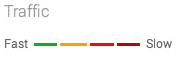
What are the colored lines representing on the traffic map?
The colored lines representing traffic conditions in Canada on major highways or streets refer to the speed at which one can travel on that road.
- The dreaded Red lines on the map mean highway traffic is moving at less than 25 miles / 40.2 km per hour and could indicate an accident or congestion on that route.
- Yellow lines on the map indicate that traffic moves faster, from 25 to 50 miles / 40.2 to 80.46 km per hour.
- Green lines on the traffic map indicate zipping along at 50 miles / 80.46 km per hour or more.
- If you see Grey lines on the map, it indicates no traffic information available at the time.
- The red-black line on the map indicates extremely slow or stopped traffic.
Speed limits in Canada
Canada is often considered one of the most beautiful places in the world to drive. The country is home to various roads, ranging from single-lane highways to twisty mountain passes. This means there are many conditions for driving in Canada, and each will require different speed limits. Road conditions such as surface quality, weather, and time of day affect how fast you can safely drive.
Speed limits in Canada vary by province. Speed limits can be as low as 30 km/h in Quebec or as high as 110km in Alberta. British Columbia’s speed limit is 60 km/h unless otherwise posted. Quebec is the only province where municipalities can establish speed limits by posting signs along main routes.
Canada has various driving conditions, meaning the speed limits vary accordingly. For example, in densely populated areas like Montreal, Quebec City, and Toronto, the speed limit is 50 km/h. In these cities, pedestrians and cyclists can often be on the streets. Other places where pedestrians are present have lower speed limits.
You should always obey these signs if they are posted.