
This interactive map shows the live traffic conditions in Alberta, Canada. Please feel free to navigate the map to your desired position and use the menu in the bottom-right corner of the frame to change the map layer from normal to satellite or terrain. You may also view public transport lines and traffic incident layers on the map below.
If you wish to search for a specific city or area in Canada, use the Traffic conditions menu above. For Driving directions in Canada, click here: Route Planner or here if you are looking for Google Maps Canada.
You may look for traffic conditions for the following Canadian cities on this live traffic map: Airdrie, Brooks, Calgary, Camrose, Chestermere, Cold Lake, Edmonton, Fort Saskatchewan, Grande Prairie, Lacombe, Leduc, Lethbridge, Lloydminster, Medicine Hat, Red Deer, Spruce Grove, St. Albert, Wetaskiwin.
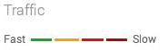
What are the colored lines represented on the Traffic Map in Alberta?
The colored lines representing traffic conditions in Canada on major highways or streets refer to the speed at which one can travel on that road.
The dreaded Red lines on the map mean highway traffic is moving at less than 25 miles / 40.2 km per hour and could indicate an accident or congestion on that route.
Yellow lines on the map indicate that traffic is moving faster, from 25 to 50 miles / 40.2 to 80.46 km per hour.
Green lines on the traffic map indicate zipping along at 50 miles / 80.46 km per hour or more.
If you see Grey lines on the map, it indicates no traffic information available at the time.
The red-black line on the map indicates extremely slow or stopped traffic
About Alberta, Canada
Alberta is a western province of Canada. With an estimated population of 4,067,175 as of the 2016 census, it is Canada’s fourth-most populous province and the most populous of Canada’s three prairie provinces. Its area is about 660,000 square kilometers (250,000 sq mi). Alberta and its neighbor Saskatchewan were districts of the Northwest Territories until they were established as provinces on September 1, 1905. The premier has been Rachel Notley since May 2015.
Alberta is bounded by the provinces of British Columbia to the west, Saskatchewan to the east, the Northwest Territories to the north, and the U.S. state of Montana to the south. Alberta is one of three Canadian provinces and territories to border only a single U.S. state and one of only two landlocked provinces. It has a predominantly Humid continental climate, with stark contrasts over a year. Still, seasonal temperature average swings are smaller than in areas further east due to winters being warmed by occasional chinook winds bringing sudden warming.
Alberta’s capital, Edmonton, is near the geographic center of the province and is the primary supply and service hub for Canada’s crude oil, the Athabasca oil sands, and other northern resource industries.
About 290 km (180 mi) south of the capital is Calgary, the largest city in Alberta. Calgary and Edmonton center Alberta’s two census metropolitan areas have populations exceeding one million, while the province has 16 census agglomerations.
Tourist destinations in the province include Banff, Canmore, Drumheller, Jasper, Sylvan Lake, and Lake Louise.
Road
Alberta has over 181,000 km (112,000 mi) of highways and roads, of which nearly 41,000 km (25,000 mi) are paved. The main north-south corridor is Highway 2, which begins south of Cardston at the Carway border crossing and is part of the CANAMEX Corridor. Highway 4, which effectively extends Interstate 15 into Alberta and is the busiest U.S. gateway to the province, begins at the Coutts border crossing and ends at Lethbridge. Highway 3 joins Lethbridge to Fort Macleod and links Highway 2 to Highway 4. Highway 2 travels north through Fort Macleod, Calgary, Red Deer, and Edmonton.
North of Edmonton, the highway continues to Athabasca, then northwesterly along the south shore of Lesser Slave Lake into High Prairie, north to Peace River, west to Fairview, and finally south to Grande Prairie, where it ends at an interchange with Highway 43. Highway 2 between Calgary and Edmonton has been named the Queen Elizabeth II Highway to commemorate the monarch’s visit in 2005. Highway 2 is supplemented by two parallel highways: Highway 22, west of Highway 2, known as Cowboy Trail, and Highway 21, east of Highway 2. Highway 43 travels northwest into Grande Prairie and the Peace River Country; Highway 63 travels northeast to Fort McMurray, the location of the Athabasca oil sands.
Alberta has two main east-west corridors. The southern corridor, part of the Trans-Canada Highway system, enters the province near Medicine Hat, runs westward through Calgary, and leaves Alberta through Banff National Park. The northern corridor, also part of the Trans-Canada network and known as the Yellowhead Highway (Highway 16), runs west from Lloydminster in eastern Alberta, through Edmonton and Jasper National Park into British Columbia. One of the most scenic drives is along the Icefields Parkway, which runs for 228 km (142 mi) between Jasper and Lake Louise, with mountain ranges and glaciers on either side of its length. A third corridor stretches across southern Alberta; Highway 3 runs between Crowsnest Pass and Medicine Hat through Lethbridge and forms the eastern portion of the Crowsnest Highway. Another major corridor through central Alberta is Highway 11 (also known as the David Thompson Highway), which runs east from the Saskatchewan River Crossing in Banff National Park through Rocky Mountain House and Red Deer, connecting with Highway 12, 20 km (12 mi) west of Stettler. The highway connects many smaller towns in central Alberta with Calgary and Edmonton as it crosses Highway 2 just west of Red Deer.
Urban stretches of Alberta’s major highways and freeways are often called trails. For example, Highway 2, the main north-south highway in the province, is called Deerfoot Trail as it passes through Calgary but becomes Calgary Trail (for southbound traffic) and Gateway Boulevard (for northbound traffic) as it enters Edmonton and then turns into St. Albert Trail as it leaves Edmonton for the City of St. Albert. Calgary, in particular, has a tradition of calling its most extensive urban expressway trails and naming many of them after prominent First Nations individuals and tribes, such as Crowchild Trail, Deerfoot Trail, and Stoney Trail.
Public transit
Calgary, Edmonton, Red Deer, Medicine Hat, and Lethbridge have substantial public transit systems. In addition to buses, Calgary and Edmonton operate light rail transit (LRT) systems. Edmonton LRT, which is underground in the downtown core and on the surface outside the CBD, was the first of the modern generation of light rail systems to be built in North America. At the same time, the Calgary C-Train has one of the highest numbers of daily riders of any LRT system in North America.
Air
Alberta is well-connected by air, with international airports in both Calgary and Edmonton. Calgary International Airport and Edmonton International Airport are the fourth- and fifth-busiest in Canada, respectively. Calgary’s airport is a hub for WestJet Airlines and a regional hub for Air Canada. Calgary’s airport primarily serves the Canadian prairie provinces (Alberta, Saskatchewan, and Manitoba) for connecting flights to British Columbia, eastern Canada, 15 major U.S. centers, nine European airports, one Asian airport, and four destinations in Mexico and the Caribbean. Edmonton’s airport acts as a hub for the Canadian north. It connects to all major Canadian airports, ten major U.S. airports, 3 European airports, and 6 Mexican and Caribbean airports.
Rail
More than 9,000 km (5,600 mi) operate a mainline railway in Alberta. The vast majority of this trackage is owned by the Canadian Pacific Railway and Canadian National Railway companies, which operate railway freight across the province. Additional rail freight service in the province is provided by two shortline railways: the Battle River Railway and Forty Mile Rail. Passenger trains include Via Rail’s Canadian (Toronto–Vancouver) or Jasper-Prince Rupert trains, which use the CN mainline and pass through Jasper National Park and parallel the Yellowhead Highway during at least part of their routes. The Rocky Mountaineer operates two sections: one from Vancouver to Banff and Calgary over CP tracks and a section that travels over CN tracks to Jasper.
Source: Wikipedia.