
Canadian Shield Forest Lands is a region in Canada that was created by the remnants of glaciers that left the earth’s surface over 10,000 years ago. Here, you can find some of the world’s most pristine and untouched forests!
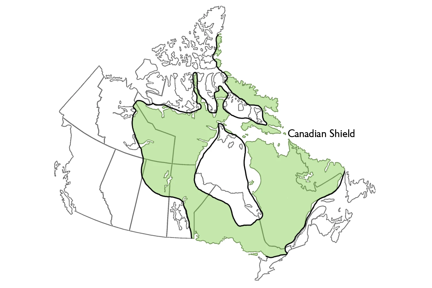
The Canadian Shield is a unique geologic region in North America composed of the continent’s most ancient surface rock. It covers more than one-half of the country’s land area and is responsible for the physical separation of the east from the west of Canada. Hudson Bay lies in the heart of the Shield. The Shield has vast resource wealth, including minerals, waterpower, and forests. It also has a low population due to the poor quality of the soil and lack of transportation options.
The other sizeable physiographic region in Canada is the Canadian Shield Forest Lands, which includes 32% of the land surface. Even if you exclude the Arctic Shield, it still is 48% of Canada’s land area. It is a vast, saucer-shaped region: the rim on its south, east and northeast sides like that of a soup plate; the center a sedimentary rock basin, and the southern fringe underlies the Hudson Bay Lowland.
The Shield is composed of Precambrian rocks that were created during many past periods of mountain building. It remained fixed over the last billion years, remaining unaffected by the influence of plate tectonics and atmospheric change. The Shield has been relatively stable recently, giving its surface a level, rolling look.
The southeastern and eastern sides of the Shield were uplifted more recently due to geological influences, which is why glacial erosion had little effect except on the eastern border. Approximately half of the Shield is classified as upland. Extending from northwestern Québec through northern Ontario, Manitoba, Saskatchewan, and southern Nunavut to northwestern mainland Nunavut and the eastern Mackenzie districts in the Northwest Territories. This terrain (200–500 m elevation) is upland only under its elevation above the Hudson Bay Lowland and the Interior Plains that border it. The bedrock in this area is smoothed by a thin layer of glacial till, which covers the bedrock beneath it. Given that the bedrock is positioned at about 50-60 meters, the lower ground has been smoothed by a thin layer of glacial till and sediment from lakes.
The eastern portion of the Canadian Shield dominates Canada. The elevation increases from 300 meters near the coast to 900 meters in central Labrador and Quebec. Relief of 150-300 meters is caused by natural erosion in the higher terrain. Certain areas on the Shield, such as uplands and plateaus, are broken up by hills and valleys. This is due to the erosion of linear geological features formed in former mountain belts.
The terrain on the east and southeast side of the Shield is classified as highland, with heights ranging between 800-1,500 meters. It has rolling plateaus with deep cuts caused by glacial troughs, giving it a fjord-like appearance. The northern Highlands stand at 500-900 m and have isolated summits that reach 1,000-1,200 meters.
Recent research has demonstrated that the two shield zones in Northern Canada, which extend east and west of Hudson Bay, were the primary outlets for the ice sheet during the last glaciation. This area is flooded by lakes, which partially cover the land. The lakes are usually found around previously higher areas. During the ice age, glaciers and ice created uneven terrain that would occasionally surface and create one of these bodies of water.
The Google Maps of the Canadian Shield Forest Lands
The Canadian Shield is a region of ancient rock that surrounds Hudson Bay. It spans Eastern Canada, Northeastern Canada, and Eastern Central Canada.
The Central Canadian Shield Forests ecoregion includes much of boreal northern Quebec and Ontario, north of the temperate-boreal transition forests, south of the taiga, and west to include the northeastern shore of Lake Superior.
Canada has a region called the Canadian Shield that wraps around Hudson Bay. This is Canada’s most extensive geographical feature, and it stretches east to Labrador, south to Kingston on Lake Ontario, and northwest as far as the Arctic Ocean.