
The Arctic and Subarctic Lands of Canada make up nearly 40% of the country’s total landmass. Despite their vast size, these regions are home to less than 1% of the Canadian population. Most people who live in the Arctic and Subarctic are Indigenous, and many still follow a traditional way of life. This article discusses the people and landscapes of this unique region.
The Arctic Lands
In the Arctic, Canada is home to some of the most stunning and unique landscapes in the world. This region is truly a natural wonder, from the snow-capped mountains and glaciers of the Canadian Rockies to the vast tundra of the Arctic Circle.
The Arctic North comprises approximately 40 percent of Canada’s land area and includes the Yukon, Northwest Territories, and Nunavut. The region “overlaps” the Canadian Shield to both the north and east. The tundra is a cold, barren, windswept region north of the tree line in the boreal forest. Despite its harsh conditions, the tundra has been home to the Inuit people for thousands of years. The permafrost layer of the tundra’s soil is frozen year-round, with a shallow covering of surface soil that thaws during the summer months. Even though the frost-free season is brief, the almost-constant sunlight coaxes small delicate flowers, lichens, and mosses to life. The ground often becomes swampy during this time of year due to poor drainage. The snow that does thaw cannot seep into the frozen ground, so it remains on the surface. The resulting bogs of spongy surface soil are called “muskeg.”
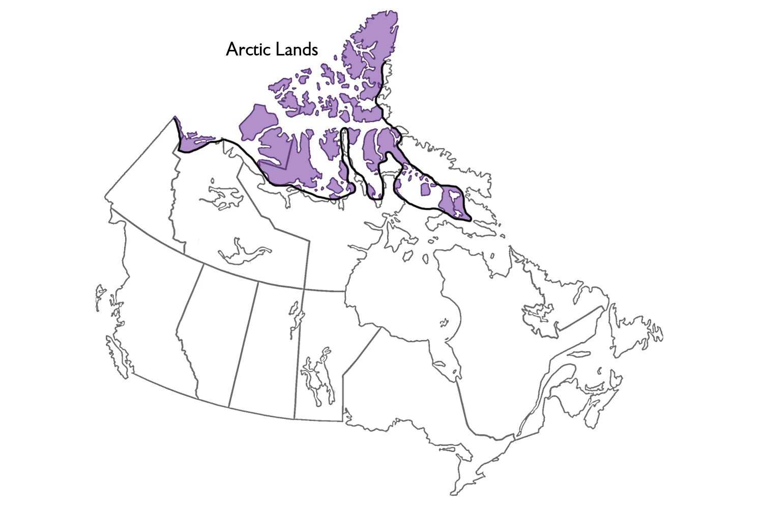
Canada’s Arctic Lands are generally thought to lie north of the treeline and cover 2.6 million km2 (26 percent of the country). They include the Arctic Coastal Plains and Lowlands, the High Arctic’s Innuitian Region, and parts of the Canadian Shield in Nunavut, northern Québec, and Labrador. However, extensive areas of Subarctic Lands must also be recognized. Canada’s Arctic and Subarctic Lands comprise nearly 40–45 percent of Canada’s land surface.
If you’re looking to get off the beaten path and explore some of Canada’s most remote and untouched territory, then a trip to the Arctic is definitely for you. Whether hiking, camping, or just taking in the breathtaking scenery, there’s no shortage of adventures in this magical part of the world.
Geological Structure and Lithology
Canada’s Arctic and Subarctic Lands are situated on some of the world’s oldest continental crust. This ancient crust is characterized by a variety of different rocks and minerals, which provide information about the Earth’s history. The study of geology is essential for understanding the evolution of our planet and the processes that continue to shape it today.
The Arctic and Subarctic Lands are home to various geological features, such as mountains, valleys, plains, and plateaus. These features were formed by various processes, such as erosion, tectonic activity, and volcanic activity. The rocks and minerals that make up these features can tell us a lot about the history of the Earth and the forces that have shaped it.
Geological structure and lithology (i.e., physical characteristics of rock) largely shape the landscape. For example, the mainland east of Great Bear and Great Slave lakes, the Ungava Peninsula, and most of Baffin Island is part of the Canadian Shield and are composed of resistant igneous, metamorphic and sedimentary rock. Higher elevations consist of bedrock outcrops, while angular rock-rubble accumulations cover upland surfaces and upper valley-side slopes. Bedrock is disrupted by joint and fissure widening and separating it into angular blocks. By contrast, areas of unconsolidated sediments from the Paleocene to Quaternary periods (65 million to 10,000 years ago) form more undulating, poorly drained lowland terrain. Several distinctive landforms occur in the Arctic Lands, most often associated with permafrost and ground ice growth. Tundra polygons, a tortoise-shell pattern of cracks up to 30 m apart with ice wedges below the cracks, cover many thousands of square kilometers. Other distinctive periglacial landforms are pingos, over 1,500 of which have been counted near the Mackenzie Delta.
Studying the geology of the Arctic and Subarctic Lands can help us better understand the Earth’s history and the processes that continue to shape our planet today.
Glaciation
Glaciers are a crucial part of Canada’s Arctic and Subarctic Lands. They play a role in the formation of the landscape and the climate. The glaciers also provide fresh water for the people and animals in these areas.
The eastern rim, extending from Labrador north along Baffin Island and into Ellesmere Island, is a mountainous zone with 1,500 m and higher elevations in the north and a heavy fjord coast. Glaciers cover about five percent of the Arctic land surface. The zone between the Shield and the Western Cordillera is a Palaeozoic plain (542–253 million years old) gently sloping downwards from 500 m in elevation to the Arctic Ocean. The islands are primarily sedimentary rocks forming plains, uplands, and hills. The rock layers in the south are mainly flat-lying, but in the Arctic Archipelago, they have been folded and eroded. Surface elevations rise from near sea level in the northwest to the high mountain rim in the east. Faulting followed by further deepening during glaciation may have caused the many channels among the islands.
Arctic or Subarctic in Nature
There are many different ways to experience Canada’s Arctic and Subarctic regions. One way is through its vast and unique landscapes. The Arctic is home to some of the world’s most breathtaking scenery, from the snow-capped mountains and pristine valleys of the Rockies to the stunning coastline of the Arctic Ocean.
Another way to experience these regions is through the people who live there. The Inuit have a long and rich history in the Arctic, and their culture is integral to life in the region.
Canada’s Arctic lands are either Arctic or subarctic. The boundary between the two approximates the northern limit of trees. This is a zone, 30–150 km in extent, north of which trees can no longer survive. Ecologists refer to the barren, treeless Arctic as tundra. The tundra progressively changes into a polar desert at extremely high latitudes as the climate becomes colder and drier. The treeline also approximates the southern boundary of the continuous permafrost zone; that is, north of the tree line, the terrain is perennially frozen, and the surface thaws for only two-to-three months each year.
Canada’s Arctic and Subarctic regions are also home to a wide variety of wildlife. From caribou and polar bears to arctic foxes and wolves, there are countless opportunities to see amazing animals in their natural habitats. Whether you’re looking for adventure, relaxation, or education, Canada’s Arctic and Subarctic regions offer something for everyone.
Lakes and Rivers
Canada’s Arctic and Subarctic regions are home to some of the most beautiful and pristine lakes and rivers in the world. From the Great Bear Lake in the West to the Great Lakes in the East, these bodies of water offer a unique and unforgettable experience for any visitor.
Lakes and rivers are ice-free from June to October in the south and from July to August in the north; they are ice-covered for the rest of the year. The largest river in Canada, the Mackenzie, flows north from Great Slave Lake and empties into the Beaufort Sea.
Whether you’re looking to fish, paddle, or take in stunning scenery, a trip to one of these lakes or rivers will leave you with lasting memories.
The Google Maps of the Arctic and Subarctic Lands of Canada
Interactive Google maps of Canada; Search for a place, zoom, look at the Street View, and create free driving directions with Google maps. Click here if you’re looking for free Driving Directions in Canada.